Source: The Stamp Atlas by Stuart Rossiter & John Flower, 1986, Macdonald & Co; All About Post Cards by W.J. Scott, August 1903, Scott & Wilson, Leeds.
Blue, Red, and Green At the 2nd congress of the Universal Postal Union in 1878 the member countries agreed to introduce uniform colours of the stamps of blue for the lowest letter rate, red for postcards, and green for the lowest printed matter rate. In this way the post office personnel in the recipient countries could better control the correctness of the stamping instead of having to convert the many different currencies in which stamps from all over the world were issued .
Austria


Bavaria
Bavaria was established in 1804. it issued its first postcard in 1870. Its stamps ceased to be valid on 30 June 1920.


The card brought out to celebrate the Nuremberg Exhibition of 1882 was the first illustrated official card. My card illustrates the 1896 Bavarian State Exhibition.

Bavarian State Exhibition held in Nuremberg in 1896.
The Bavarian State Trade, Industry and Art Exhibition was held three times in Nuremberg which had developed into the industrial heart of Bavaria. In 1882 products from agriculture, industry and arts and crafts were on display on 120,000 square meters of exhibition space. In order to enable small businesses to take part, a support fund of 25,000 marks was set up. The area was electrically illuminated by electrical pioneer Sigmund Schuckert. The event was a huge success for the city, with 2 million visitors.
The second exhibition in the Noris took place from 14 May to 15 October 1896. The exhibition area had to be expanded to 200,000 square meters in order to be able to offer the 3,300 exhibitors enough space. This show was served by electric tram but, interest remained below expectations; Only 1.8 million visitors. It was a success for the exhibiting companies with over 9,000 deals were made with a total value of two million marks. Another 9,000 follow-up deals with a volume of 1.5 million marks were added. The horticultural facilities of this state exhibition were preserved for the citizens of Nuremberg as a city park.
The 1896 Exhibition was the occasion of an international chess tournament from which emerged Tarrasch’s Luck Table showing that the champion won his games by luck while Tarrasch himself was the more deserved winner.
On the occasion of Nuremberg’s 100-year membership in Bavaria, the state exhibition of 1906 was again held in the Franconian metropolis. This time the exhibition took place on the specially-created Luitpoldhain Park, later the scene of Nazi rallies. Not everyone agreed about the reason for the exhibition:
We want to leave unexamined whether it was at all a blessing that large parts of Franconia and the free imperial city of Nuremberg were annexed to the backward Old Bavaria. … “
Nürnberger Anzeiger 1902
Source: Bayerische Landes-Gewerbe-, Industrie- und Kunstausstellung in Nürnberg – 1882, 1896, 1906


Belgium
Belgium issued its first postcard in 1871.


The use of reply cards created a lot of challenges as their usage required the collaboration and common understanding of two post offices in two countries. The foundation for this were the regulations of the Universal Postal Union.
Bohemia

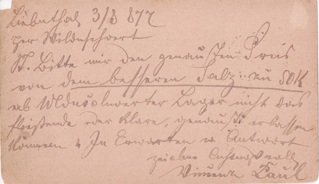
The Kingdom of Bohemia was a medieval and early modern monarchy in Central Europe, the predecessor of the modern Czech Republic. Bohemia came under the control of Charlemagne (Charles the Great) towards the end of the 8th century. Otto the Great (912 to 973) firmly integrated the Duchy of Bohemia into the Holy Roman Empire which was created on 2 February 962 when Otto became its first Holy Roman Emperor. In the 12th century Bohemia became the Kingdom of Bohemia carved out from the previous Duchy of Bohemia. In 1526 the Austrian Habsburgs obtained control of the Kingdom of Bohemia and it became part of the Austrian Duchy which was the Austrian Empire from 1804. When the Holy Roman Empire was dissolved on 6 August 1806, Bohemia remained part of what was now the Empire of Austria. With Napoleon Bonaparte’s final defeat, the German Confederation was established in 1815 by the Congress of Vienna, Bohemia remaining part of the Empire of Austria, now part of the Prussian-led German Confederation. With Austria’s defeat by Prussia in the Seven Weeks War of 1866, the Confederation was abolished. The Austrian Empire retained Bohemia until the Treaty of Neuilly in 1919 when an independent Czechoslovakia was created. In March 1939 Germany once again annexed Bohemia and Moravia as a Protectorate which lasted until May 1945.
This card was written on 3 August 1877 when Bohemia was part of the Austrian Empire.
Bosnia Herzegovina
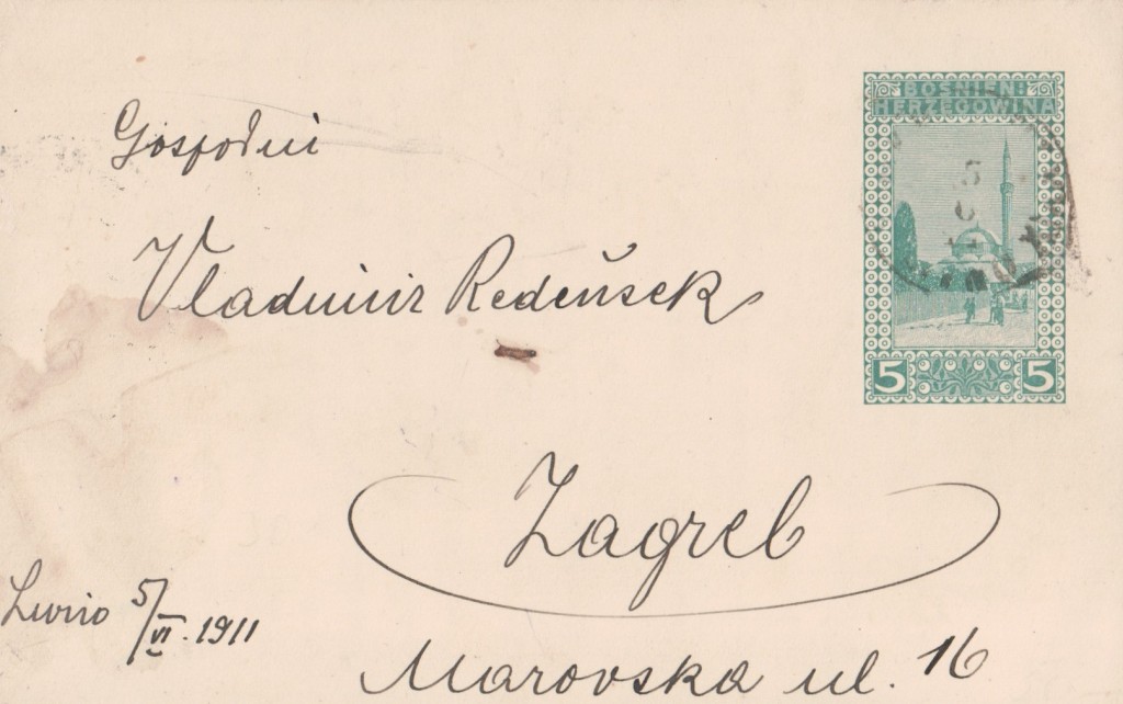

Two associated provinces of the Ottoman Empire came together in the 15th century and remained part of the Empire until the end of the Russo-Turkish war in 1878. After that they were under Austrian control and issued their first postcard in 1879.
Formally annexed by the Austro-Hungarian Empire in 1908, the first stamps under this regime were issued in 1910 and this card was postally used in 1911. It was all-change again after WWI when the Austro-Hungarian Empire came to an end and the provinces joined what in 1939 became Yugoslavia. Following the dissolution of Yugoslavia, the republic proclaimed independence in 1992, which was followed by the Bosnian War, lasting until late 1995 and culminating with the Dayton Agreement.
Bulgaria
- ПОЩЩЕНСКА КАРТА
- ЗА ВѪТРЪШША КОРРЕСПДЕШЩИЯ
- САМО АДРЕССЪТЪ СЕ ПИШЕ НА ТАЯ СТРАНА
POSTAL CARD FOR THE FOREIGN CORRESPONDENT
ONLY THE ADDRESS IS WRITTEN ON THIS SIDE


Bulgaria was conquered by the Turks in 1396 and was a province of the Ottoman Empire until 1877. It revolted in 1876 in support of Bosnia-Herzegovina when it was annexed by Austria-Hungary. This revolt was suppressed by the Turks with great cruelty which drew the attention of the Great Powers to the area. Bulgaria was the scene of much of the fighting during the Russo-Turkish war of 1877-8 and revolted again against Turkish control. After Russian intervention, a principality was established in 1878 north of the Balkan mountains, confirmed that year by the Treaty of Berlin.
Bulgaria thus reappeared on the map after a five-century absence.
The principality issued its own stamps from 1879. From 1881 its currency was the lev divided into 100 stozinki. It was joined by the Eastern Romalia area to the south from 1 October 1885. Bulgaria remained a principality under Turkey until it became an independent state in 1908.
This Card: Пьрво Бъпгарсно Изложение Въ Пловдивъ
First Bulgarian Exhibition In Plovdiv 1892
Inspired by the 1889 exhibition in Paris and Eiffel’s iron entrance arch tower, the exhibition was an audacious assertion of the new state’s ambitions. Plovdiv, the second-largest city in Bulgaria, standing on the banks of the Maritsa river in the historical region of Thrace had just ten months to build the park, pavilions, and hotels. The location was largely previously occupied by abandoned Turkish cemeteries and the exhibition took place on an area of 80,000 m². Court gardener Lucien Chevallas, a graduate of park art in Paris, supervised the landscaping and paving of the park’s six central avenues, in which 264 trees were planted. To provide shelter from the notorious Plovdiv heat, trees at least 10-years-old were chosen.
Participants came from 24 different countries and during the two and a half months of the fair, its pavilions were visited by 161,727 people. During the exhibition, for the first time in Bulgaria, electric lighting and a telephone were demonstrated with a connection with Sofia. In the foreign pavilions, technical innovations made a strong impression – light bulbs, Thomas Edison ‘s phonograph and the weapons of the German company “Krupp”.
The album “First Bulgarian Agricultural and Industrial Exhibition in Plovdiv, 1892” was presented to Prince Ferdinand I – patron of the exhibition. This card shows the main state pavilion, the work of the main architect of the exhibition, Heinrich Mayer. The Plovdiv International Fair has been held annually since 1892, and is the largest and oldest fair in southeastern Europe.
The green five stozinki stamp was in use from 1890.
This card: ОТВОРЕНО ПИСМО
OPEN LETTER
На тая страна се пише само адресса
Only the address is written on this side
Sources: DW; https://www.svet.bg/
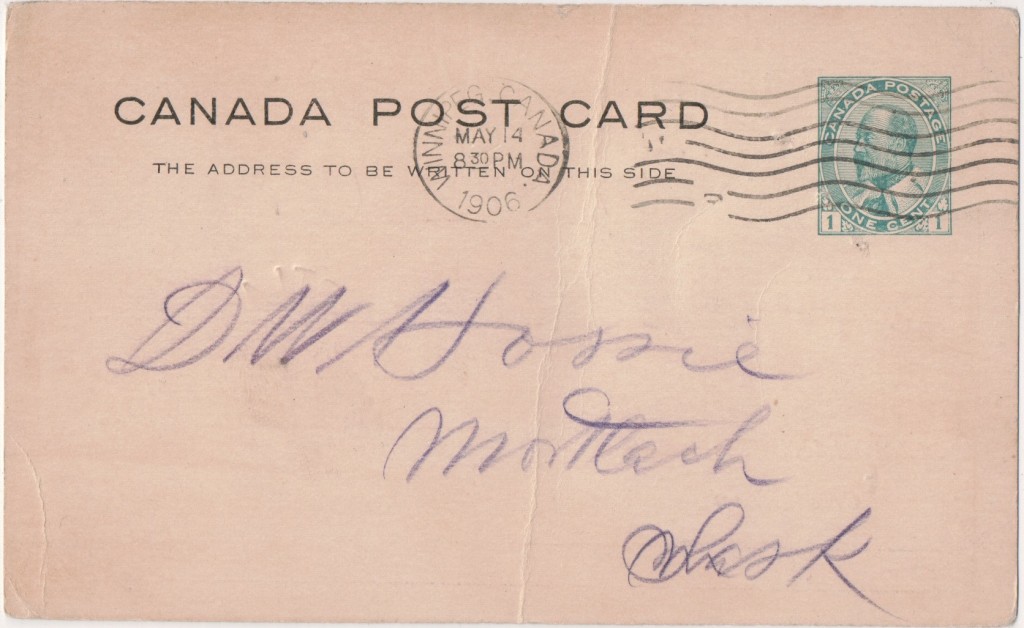
Canada


The Great West Saddlery Company Limited
- OFFICE OF The Great West Saddlery Co., Ltd. SADDLERY and LEATHER MARKET STREET EAST WINNIPEG MANITOBA

Elisha Frederick Hutchings (13 June 1855 to 14 April 1930) saddle maker, merchant, financier and politician. Ontarian Hutchings arrived in Winnipeg in 1876 where he was educated at Alexander Begg’s night school. In 1877 he bought a junior partnership in Stabler and Caswell, harness makers. A year later he joined Robert Stalker in the Great West Saddlery Company, which Hutchings built into a major operation by 1900. The firm manufactured saddles, harnesses, collars, whips, valises, and leather bindings, later expanded into automobile accessories, shoe bindings, and leather goods.
By the early 20th century, Hutchings was President of the Scott Saddlery Company, Royal Oak Saddlery Company, Brick & Tile Company, Capital Loan Company, and Bird’s Hill Land & Gravel Company, and Penniac Reef Gold Mines. He was a Director of the Canadian Fire Insurance Company, a member of the advisor board of the Great Western Loan Company, and a shareholder of the Winnipeg Sanitarium Association Limited. In 1910 he was listed by the Winnipeg Telegram as one of Winnipeg’s 19 millionaires.
Hutchings collected war trophies and memorabilia and he was a founding member of the Carleton Club. His Winnipeg homes were designed by architects Herbert B. Rugh and L. A. Wardell. He served four terms on Winnipeg City Council, being at one time chairman of the City Sinking Fund trustees. He is commemorated by Hutchings Street. A sinking fund is a fund established by setting aside revenue over a period of time to fund a future capital expense, or repayment of a long-term debt.
The business had two premises in Market Avenue; 112 is a four-storey brick structure was designed and constructed in 1898 by James McDiarmid, at an estimated cost of $40,000. The basement was devoted to his firm’s major product, horse collars. Company offices were on the ground floor, along with shipping and receiving areas. The second floor was used for storage, mostly of saddles. A sample room and more storage space was on the third floor, and the top floor was used for manufacturing boots and shoes, saddles, cases, and other leather products. Additions were made to the building in 1903, 1909, and 1929. The company continued to occupy the building until 1962.
The company also built 113 Market Avenue, a six-storey brick factory building in 1910 to complement the existing warehouse across the street. Designed by Winnipeg architect W. W. Blair, it was used by the firm into the 1940s then by garment manufacturers in the 1950s and 1960s. It was vacant by 1978. It was renovated into cooperative residential housing in the late 1980s.
Sources: Manitoba Historical Society Archives
Cape of Good Hope
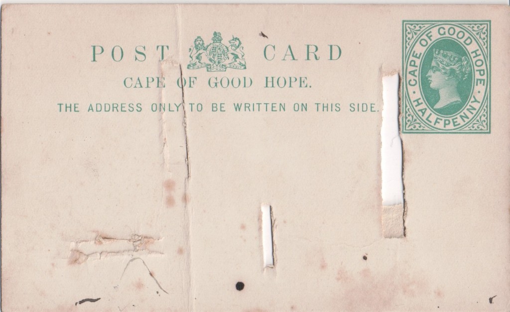

During the Napoleonic Wars, the Dutch Republic was occupied by the French in 1795. Thus the Cape Colony became a French vassal and enemy of the British. The United Kingdom invaded and occupied the Cape Colony that same year. The British relinquished control of the territory in 1803 but returned and reoccupied the Colony on 19 January 1806 following the Battle of Blaauwberg.
In the War of the Sixth Coalition (March 1813 to May 1814), a coalition of Austria, Prussia, Russia, the United Kingdom, Portugal, Sweden, Spain and a number of German States defeated France and drove Napoleon into exile on Elba. The Dutch ceded the territory to the British in the Anglo-Dutch Treaty of 1814 The Cape was then administered as the Cape Colony and issued its first postcard in 1878. It remained a British colony until it was incorporated into the independent Union of South Africa in 1910. British control of the colony led Boer settlers to make the Great Trek northwards.
Ceylon
Ceylon issued its first postcards in 1872. This style was issued from 1899.

Chile


First founded in 1795 as Murray, Draper, Fairham & Company, the American Bank Note Company developed into the United States’ foremost high security engraving and printing firm in the years prior to the Civil War. It produced paper money, postage stamps, stock and bond certificates. After the Civil War, it produced paper money and stamps for foreign governments, including Canada and Haiti. In 1879, it merged with the National Bank Note and Continental Bank Note companies.
Between 1535 and 1541 the Spanish gained a foothold in northern Chile and founded Santiago. Bernard O’Higgins led Chile to independence in 1818. A regular postal service between Buenos Aires and Santiago was established in 1748 – taking 15 days. Chile issued its first postcards in 1871. This style, featuring Columbus, was current in 1902.
Costa Rica


Costa Rica is a country in Central America, bordered by Nicaragua to the north, Panama to the east and south, the Pacific Ocean to the west and south and the Caribbean Sea to the east.
Cuba


The Cuban War of Independence fought from 1895 to 1898, was the last of three liberation wars that Cuba fought against Spain. The final three months of the conflict escalated to become the 1898 Spanish–American War, with United States forces being deployed in Cuba, Puerto Rico, and the Philippine Islands against Spain. After the War, Cuba came under US control until 1902 during which time an independent republic was declared which Spain was forced to recognise on 21 February 1901. It remained politically turbulent and was re-occupied by the Americans.
This Card: The stamp is integrated and bears the image of José Julián Martí Pérez (28 January 1853 to 19 May1895) a Cuban poet, philosopher, essayist, journalist, translator, professor, and publisher, who is considered a Cuban national hero because of his role in the liberation of his country. He was a key figure in the planning and execution of Cuban War of Independence, as well as the designer of the Cuban Revolutionary Party and its ideology. He died in military action during the Battle of Dos Ríos and his death was used as a cry for Cuban independence from Spain by both the Cuban revolutionaries and those Cubans previously reluctant to start a revolt. Martí’s ideology serves as the main driving force of the ruling Cuban Communist Party
Source: wikipedia further reading: Filatelia de Cuba
This addressee: James S. Mason & Company, North Front Street, Philadelphia. Mason was a prominent manufacturer of blacking and inks. They were in business from at least 1854 and at this address until 1919.
Source: Library of Congress
Denmark


Denmark’s postal history begins with an ordinance of 24 December 1624 by King Christian IV, establishing a national postal service. This service consisted of nine main routes, and was to be operated by the mayor of Copenhagen and several guilds. Initially the mail was carried by foot, with riders being used after 1640. The state took over control in 1711. The first steamship carrying mail was the SS Caledonia, which began carrying mail between Copenhagen and Kiel on 1 July 1819.
In 1873, the currency was changed to the decimal kroner, which necessitated new stamps. They were changed again in 1882 when the Universal Postal Union standardized on particular colours of stamps for international mail. The “Arms type” was designed to meet this requirement; the 5 øre printed in green, and the 20 øre in blue, followed up in 1885 by a 10 øre in red and his price one million.
Denmark allowed a message on the address side of postcards on 1 June 1905
Source: wikipedia
France


France first issued postcards in 1973. This card was printed in June 1878 in that style. Unlike most official cards, it is not pre-stamped.
Germany


Italy


Kamerun (German Cameroon)


Kamerun was an African colony of the German Empire from 1884 to 1916 in today’s Republic of Cameroon. Kamerun also included northern parts of Gabon and the Congo with western parts of the Central African Republic, southwestern parts of Chad and far northeastern parts of Nigeria.
The first German trading post in the Duala area on the Kamerun River delta was established in 1868 by the Hamburg trading company C. Woermann. The firm’s primary agent in Gabon, Johannes Thormählen, expanded activities to the Kamerun River delta. In 1874, together with the Woermann agent in Liberia, Wilhelm Jantzen, the two merchants founded their own company, Jantzen & Thormählen there. Both of these West Africa houses expanded into shipping with their own sailing ships and steamers and inaugurated scheduled passenger and freight service between Hamburg and Duala. These companies and others obtained extensive acreage from local chiefs and began systematic plantation operations, including bananas. The Cameroon territory was under the informal control of the British Empire throughout the years preceding 1884, with substantial British trading operations as well.
Eventually, these companies would begin agitating for royal protection. By 1884, Adolph Woermann, as spokesman for all West African companies, petitioned the imperial foreign office for “protection” by the German Empire. This, among a number of other factors, led to Imperial Chancellor Otto von Bismarck approving the establishment of a colony. Further territory was acquired from France in 1911-12.
Six post offices including Duala were open by 1897. In November 1900, the colony received its own stamps with the motif of the imperial yacht SMY “Hohenzollern”. Built in 1892 the yacht series was used between 1900 and 1919 in the German colonies.
Duala was captured by Allied forces on 27 September 1914 and the last post office in February 1916. In March 1916 Kamerun was divided between Britain and France, an arrangement modified in 1919 when France regained the territories ceded in 1911-12.
Luxemburg


Macau & Timor


Province of Macau and Timor (1866 to 1897). The first Europeans to arrive in the region were the Portuguese in 1515. Portuguese Timor was a colonial possession of Portugal that existed between 1702 and 1975. During most of this period, Portugal shared the island of Timor with the Dutch East Indies, which was to become Indonesia. Dominican friars established a presence on the island in 1556, and the territory was declared a Portuguese colony in 1702.
Until 1844, Macao and Timor and Solor were separate territories under the jurisdiction of the Portuguese Estado da Índia (The State of India), also referred as the Portuguese State of India or simply Portuguese India, a state of the Portuguese Empire founded six years after the discovery of a sea route to the Indian subcontinent by Vasco da Gama who was a subject of the Kingdom of Portugal.
Solor is a volcanic island located off the eastern tip of Flores island in the Lesser Sunda Islands of Indonesia, in the Solor Archipelago. The island supports a small population that has been whaling for hundreds of years.
By 1836 the government of the captaincy of Timor and Solor was heavily dependent on the authorities in Macao. The two territories were represented in the Parliament of Lisbon by a single ambassador. In 1844, the two Far Eastern territories were joined to form a new province, independent from the Estado da Índia. The seat of government for the Provincia de Macau, Solor e Timor was in Macao; a subordinate governor resided in Dili, the capital and largest city of East Timor.
In 1850, Timor and Solor were declared an autonomous province. This was a period of intense territorial conflict with the Dutch, and it is likely that the elevation of the islands to the status of a separate province was intended to give the governor the power to conduct the negotiations with the Dutch that were to lead to the 1859 Treaty of Lisbon.
In 1851, Timor and Solor went back under the jurisdiction of Macao, and in 1856, the Far Eastern territories were subordinated again to the Estado da Índia. Timor again briefly became a separate colony in 1863 before being made an autonomous district within the newly formed Província de Macau e Timor in 1866. In 1897, Timor became independent from Macao, and from then on, it was directly administered by Lisbon.
Following the beginning of the Carnation Revolution (a Lisbon-instigated decolonisation process) in 1975, East Timor was invaded by Indonesia. However, the invasion was not recognized as legal by the United Nations, which continued to regard Portugal as the legal administering power of East Timor. The independence of East Timor was finally achieved in 2002 following a UN-administered transition period.
Source: Administration of Portuguese Timor (1702–1975) Chapter 2 At the Periphery of Nanyang: The Hakka Community of Timor-Leste Juliette Huber;
Memoria de Macau
Natal


In 1824, Shaka, king of the Zulu, ceded a stretch of coastal area to the British. The British proceeded to establish Port Natal (Durban), beginning settlement in 1835. In 1837, Boers entered the interior of what was to become Natal. After their leader Piet Retief and a number of his men had been massacred on the orders of the Zulu chief Dingane, the Boers defeated the Zulus in the Battle of Blood River in 1838. The Boers expelled the British and established the Republic of Natalia, with Pietermaritzburg as its capital. It was conquered by the British in 1842 and annexed in 1843; most of the Boers emigrated into the Orange or Vaal river regions. The British administration took up residence in Pietermaritzburg. Until 1856, British Natal was governed as an outlying part of the Cape Colony. Immigration was encouraged and Indians arrived from the 1860s onward. Natal issued its first postcard in 1885. On 1 May 1888 both neighbouring Zululand and Natal became members of the Universal Postal Union.
In 1893, Natal was given self-government. That year, Mohandas K. Gandhi arrived in Durban and soon began his campaign to improve the status of the Indians living in the colony. During the Boer War (1899 to 1902), Natal was the target of a number of Boer raids; Ladysmith was taken under siege, but held out. In 1900, the Boer republics were occupied by British forces. In 1910 the four colonies of the Cape, Natal, Transvaal and Orange became the single Union of South Africa.
Source: World History at KMLA
The Battle of Colenso was the third and final battle fought during the Black Week of the Second Boer War. It was fought between British and Boer forces from the independent South African Republic and Orange Free State in and around Colenso, Natal on 15 December 1899.
Shortly before the outbreak of the war, General Sir Redvers Buller was dispatched to South Africa at the head of an Army Corps, and appointed Commander-in-Chief of all British forces in South Africa.
On 24th November 1899 Lord Dundonald, Buller’s commander of mounted troops led a reconnaissance in force by 1,500 mounted infantry with a battery of field artillery towards Colenso.
After examining the Boer positions Dundonald withdrew. That day, the Boers demolished the railway bridge over the Tugela at Colenso. The road bridge was left intact.
Buller’s disastrous first attempt to cross the Tugela River and relieve Ladysmith led to 143 British fatalities, 756 wounded, and 220 captured. Boer casualties were eight killed and 30 wounded.
Source: wikipedia; BritishBattles.com
This sender: Oliver Ripton Daniel. (1867 to 1933) led a colourful life. In 1896 he sued Hugh R Denoon for defamation resulting in a case, Daniel v Denoon (1897) 18 Natal LR 125, reported on the issue of whether truth is a defence to an action for defamation and, if not, whether it it could be relevant in the assessment of damages. In 1917 he applied for a prospecting permit and, in 1922, faced insolvency.
On the same day as he sent this card (5 December 1903) Daniel posted another card from the same series to a woman in Jersey with the same message, discouraging her from sending more postcards.
Source: angloboerwar.com
Netherlands
Netherlands first issued postcards in 1871.


This card from Netherlands arrived in the German post office in Istanbul which existed between 1870 and 1914.
New South Wales

New South Wales was the first state of Australia settled by Europeans. A postal service operated between between Sydney and Parramatta from 1803 at a cost of 2d per letter. The first stamps were issued on 1 January 1850. The first postcards were issued in 1875. NSW became a member of the Universal Postal Union in 1891. In 1901 it was federated into the Commonwealth of Australia but continued to use its own stamps until 1913.
Romania


The Romanian state was formed in 1859 through a personal union of the Danubian Principalities of Moldavia and Wallachia. The new state, officially named Romania since 1866, gained independence from the Ottoman Empire in 1877. Following the outbreak of World War I, after declaring its neutrality in 1914, Romania fought on the side of the Allied Powers beginning in 1916.
However, about half of present day Romania was part of the Austro-Hungarian Empire until 1918, including the provinces of Transylvania, Bucovina, Banat Crisana and Maramures. These provinces were ruled by the Habsburgs for centuries before becoming part of Romania. The card above is from that part of the country while the card below is from the newly-formed state. The first cards were issued in 1873 with a five bani stamp.
In 1899, Austria adopted the krone as its currency which helps us date the card above.

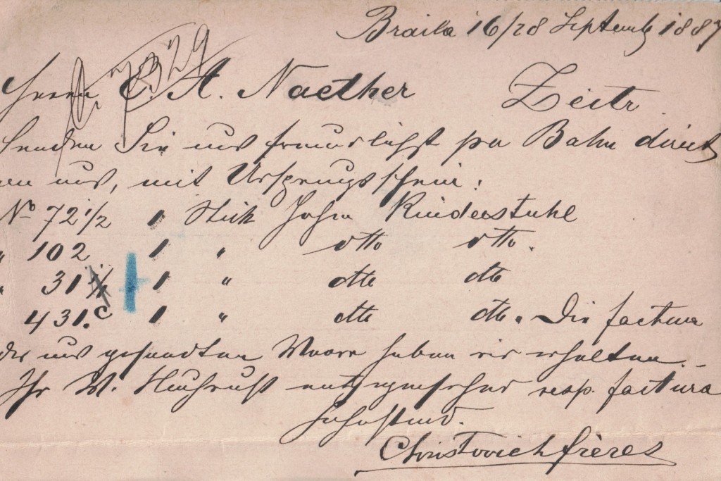
This card: This seems to be an order in 1887 by a firm called Christovich freres of Brăila, Romania, to E. A. Naether in Zeitz, a city in what is now Saxony-Anhalt in Germany. The order is for children’s high chairs, the first being 1 St. hohen Kinderstuhl .
Ernst Albert Naether (1825 to 1894) was a German entrepreneur considered the founder of the German pram industry. About 1850 Naether started to produce wooden miniature children’s trolleys in Zeitz In 1852 he exhibited his children’s pram at the Leipzig Trade Fair. In 1876 his sons Ablin and Richard took over the management of the company. In 1910 the company was transformed into an stock corporation. In 1946 like most companies in East Germany, the company was expropriated and transferred to the VEB Zekiwa.
On 10 September 1892 the Romanian Official Monitor journal published a court order against Christovich who had left no forwarding address, requiring him to carry out specified repairs at his his former tenancy. This must be urgent by now.
Russia


The heading ОТКРЫТОЕ ПИСЬМО translates as OPEN LETTER, the original Russian wording for postcard. Russia issued its first postcards in 1872.
Richard Carline in his book Pictures in the Post The Story of the Picture Postcard (1959 Gordon Fraser) reports that a ten rouble fine was imposed for including a declaration of love on a postcard.
Upper Silesia


After World War I, a number of disputed areas were placed under temporary League of Nations administration, pending plebiscites to determine which nation the populace wished to join.
Upper Silesia, a province of West Prussia bordering on Poland was ethnically mixed with both Germans and Poles; according to pre- WWI statistics, ethnic Poles formed 60 percent of the population. The Versailles Treaty mandated a plebiscite to determine ownership of the province between Weimar Germany and Poland. After the war the area was occupied by British, French, and Italian forces under an Inter-Allied Commission (CGHS) headed by a French general.
The Commission issued by stamps specifically designed for the region in three languages, German, French and Polish and were clearly responsible for this card.
Both Poles and Germans were allowed to organize campaigns in the plebiscite . Each side developed secret paramilitary forces—both financed from the opposing capitals, Warsaw and Berlin. The plebiscite area was largely cut off from normal contact with Germany. Upper Silesia was not represented in the Reichtstag, and German citizens needed visas to enter the plebiscite area.
The Poles carried out two uprisings during the campaign, in August 1919 and August 1920. The Allies restored order in each case, but the Polish insurrectionists clashed with German “volunteers,” the Freikorps. When the Second Silesian Uprising broke out, the British delegation blamed the French delegations pro-Polish bias for the ease with which the uprising had spread.
A feature of the plebiscite campaign was the growing prominence of a strong autonomist movement, the most visible branch of which was the Bund der Oberschlesier/Związek Górnoślązaków. This organization attempted to gain promises of autonomy from both states and possible future independence for Upper Silesia. The plebiscite on 20 March 1921 was indecisive, the vote nearly equally divided between Poland and Germany. The Inter-Allied Control Commission divided the territory between the two countries based on the results of the plebiscite.
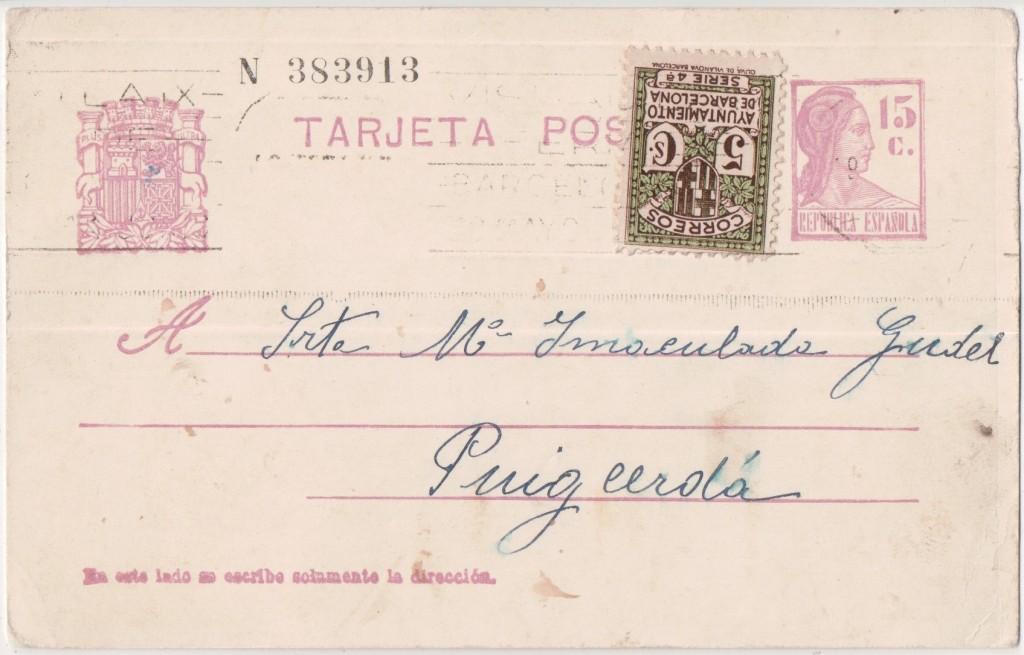
Spain
Suriname
Suriname, a former Dutch colony on the north-east coast of South America, has issued stamps since 1873. The earlier issues until it gained state autonomy in December 1954, mostly featured the head of the Dutch monarch on them. Suriname gained full independence in November 1975.
This card dates from about 1890.


Sweden
Sweden issued its first cards in 1872. This card is from the 1889 issue that was still current in 1902.


Switzerland
Switzerland issued its first postcards in 1870.


In 1900 the Swiss Federal Council organised a celebration of the 25 years anniversary of the Universal Postal Union and commissioned special stamps and postcards. The same design123 was used for 5, 10 and 25 cent stamps and postcards bearing the design to the left of the address at the 5 and 10 cent level. S. Florian, of Paris, prepared the original die from the design of D. Grasset. The printing was entrusted to Max Girardet, of Berne, and was effected in colour on white paper124. Girardet was secretary of the Swiss Society of Painters and Sculptors125 and it is not clear if he also printed the postcards. He was later prosecuted for selling used plates and proof sheets of the stamps126.
Travancore


Anchal (post) was the early postal service started in the kingdom of Travancore and Cochin before Independence of India. Travancore includes the southern tip of India The postal service was started in Travancore in 1729 by Anizham thirunal Marthandavarma and later in Cochin in 1770s. Travancore issued its first stamps in 1888. Later it was merged with the India Posts & Telegraph on 1 April 1951 after Independence of India.
The name Anchal derives from the Greek word Angelos meaning a messenger who runs on foot, the bearer of despatches. It is believed that name Anchal was given to the early post by General John Munro, the then Resident Diwan of Travancore.
United Kingdom
- FOREIGN POST CARD FOR COUNTRIES INCLUDED IN THE POSTAL UNION.


On 9 October 1874 the Treaty of Bern establishing the General Postal Union, was signed. The first UK overseas postcard was prepared following agreement by the General Postal Union that these be accepted by all member countries as part of the normal mail. At that time membership of the GPU extended mainly to those countries which we now call Western Europe, plus the USA and Egypt, and so the possible use for an overseas postcard was limited. The GPU agreement also set the postcard rate at exactly half that of the basic letter rate to countries in the Postal Union, which in the case of Britain was 2½, and so the postcard rate became l¼d. This was a unique rate which has never been repeated and it is the only time the farthing was ever used as part of a postal rate in the UK, although it was frequently used when setting the selling price of stamped stationery. The GPU agreement covering overseas postcards only allowed them to be sold at their face value and no premium could be added for printing and distribution. This was in contrast to the selling arrangements for inland cards where the cost of production was passed to the purchaser, allowing greater competition between the Post Office and private publishers. As no premium could be charged above the price of the stamp, private publishers were unable to compete with the official version and no private cards were ever produced. Membership in the Union grew so quickly during the following three years that its name was changed to the Universal Postal Union in 1878. The heading of the next issue in 1879 read “Great Britain (Grande Bretagne)”.


Stuckey’s Bank, as so often happened in the early days of banking, evolved almost imperceptibly from a general merchanting business, that of Samuel Stuckey of Langport. His bank there dated from 1772 and Langport remained its Head Office throughout the 137 years independent life of the bank. 1806 saw the opening of the Bristol Office at 50 Broad Quay. Stuckey’s Bank, a joint stock bank and the second to be formed in the country, was created in 1826 by the amalgamation of three Stuckey family banks along with a private Bristol bank. From 1828 they came under the name Stuckey’s Banking Company, also known as Bristol & Somersetshire Bank. In the heyday of Vincent Stuckey (24 March 1771 to 8 May 1845) their note-issue was the largest in England and Wales after the Bank of England and their notes were widely preferred locally.
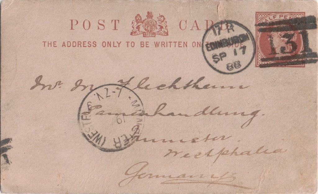

This card: Cross & Donaldson, wholesale seed and oilcake merchants. In 1875 they were at 11 Assembly Street in Leith. Thereafter in West Bowling Green Street, Leith. In 1880 they were also at 60 North Bridge, in 1886 that had changed to 41 Constitution Street, Leith and, in 1888, 19 St Giles Street, Edinburgh.
This card appears to suggest that their salesman will call on a customer in Munster, Westphalia, then a province of Prussia in a few days.
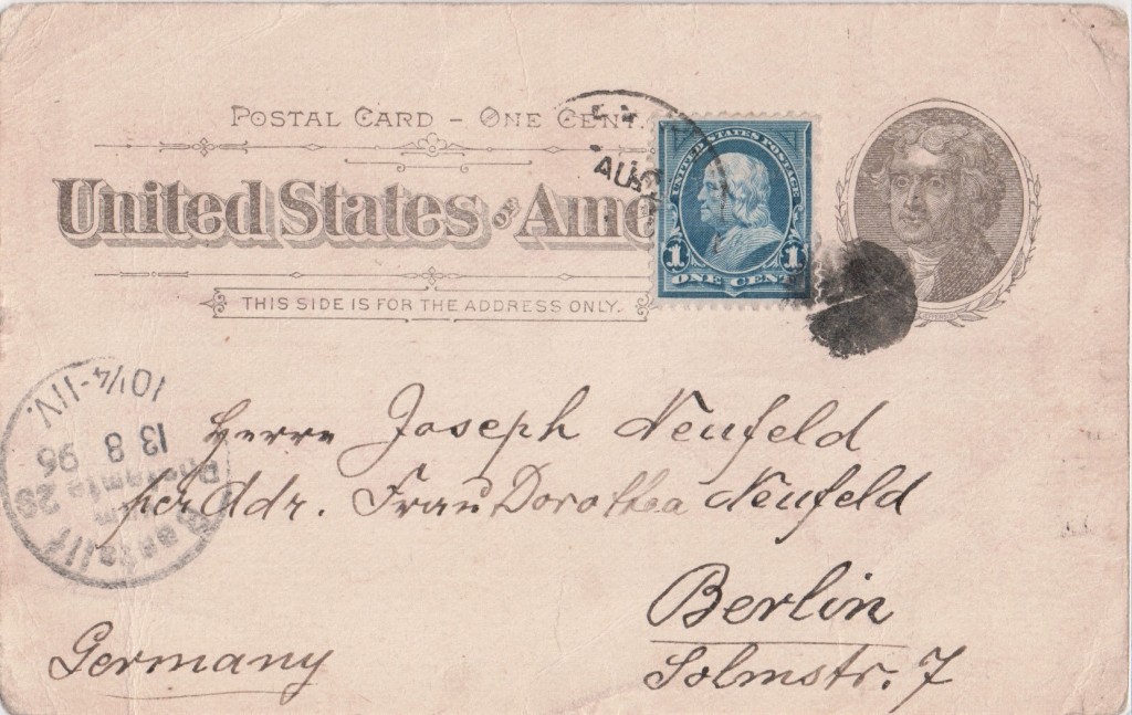
USA
USA issued its first postcards in 1873.


This card: In 1835, Connecticut merchant John Pitkin purchased the land of the Town of New Lots north of New Lots Avenue. He founded the East New York Boot, Shoe & Leather Manufacturing Company shoe factory at what is now Williams Street and Pitkin Avenue in 1838, with its sales department in New York city. Pitkin named the area East New York to signify it as the eastern end of New York City
The company obtained contracts for the labour of one hundred and fifty convicts in the Albany County Penitentiary and for the labour of two hundred and fifty boys in the Providence, R. I., Reform School. They also added the labour of the prisoners in the Rhode Island State Prison and established another factory in the city of Providence. The labour of some three hundred Albany county prisoners, then employed by a rival firm, was offered as an inducement to move its plant to Albany.
The East New York Shoe Co., 129 Duane street, are looking for the man who has been borrowing money on the strength of their reputation. He has victimized several firms in Boston and elsewhere by representing himself as buyer for the company. Notwithstanding this, the “Ballou Flexible” shoe increases in popularity, and Mr. F. E. Pitkin says it is the “boss” shoe for ladies’, misses’ and children.
The Boot & Shoe Recorder 5 October 1887
In 1880, the East New York Shoe Company had its factory department at 226 to 236 Hamilton Street, Albany and Albany Penitentiary. Charles T Whitman (died July 1906). In the spring of 1889 the contracts for penal labour were closed through adverse State legislation. The company placed advertisements seeking to recruit first-class shoe workmen in bottoming department from as far away as Boston to move to Albany.
This depression caused a reorganization of the company which was successful until the spring of 1890 when difficulties arose with the labour unions. These were partly settled in 1891 and on 28 January 1892, the Boston Daily Globe reported a settlement made in favour of their employees by the company after a two year strike. However, the financial depression beginning in 1893 made itself felt in the business and it was wound up in 1894 and 1895 all obligations honourably liquidated.
Source: Landmarks of Albany County


This seems to be an order by a firm called Christovich freres of Brăila, Romania, to E. A. Naether in Zeitz, a citiy in what is now Saxony-Anhalt in Germany. Ernst Albert Naether (1825-1894) was an important producer of strollers (see https://de.wikipedia.org/wiki/Ernst_Albert_Naether). The firrst position of the order is “1 St. hohen Kinderstuhl” (1 piece high childrens chair).
LikeLiked by 1 person